:: Picture Lanna :: ภาพล้านนาในอดีต :: คุณบุญเสริม สาตราภัย
Find Picture of
By
Keyword
Subject
Creator
:: Picture Lanna :: ภาพล้านนาในอดีต :: คุณบุญเสริม สาตราภัย
Boonserm Satrabhaya
Chiang Mai University
Hong Hoop Lamphun
National Archives of Thailand
National Archives of Thailand (Chiang Mai)
Displaying
6
of
1151
images for all of the
keyword
Aerial view
Boonserm Satrabhaya
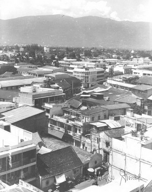
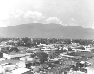
Aerial view of Chiang Mai City taken from the Nawarat Bridge towards the foothills of Doi Suthep, 1962.
Boonserm Satrabhaya
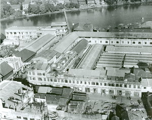
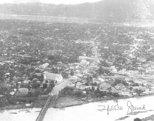
Aerial view of Kad Luang Kad Ton Lam Yai, 1953.
Boonserm Satrabhaya
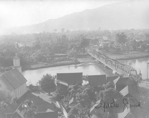
Aerial view of the Nawarat Bridge and the First Presbyterian Church. In the center of the picture is the Chedi Luang and large rubber trees that were the landmark of the old Chiang Mai City.
Boonserm Satrabhaya
Aerial view of Warorot Market and the Pun Thao Kong Shrine, 1972.
Boonserm Satrabhaya
Aerial view of Warorot Market and the Pun Thao Kong Shrine, 1972.
Boonserm Satrabhaya
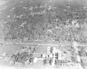
Aerial view, to the left is the Inthawarorot Road, Wat Phabong and Wat Prasat. The far north is the building of the Maharaj Hospital, 1969.
<< Found 6 Records >>
Current page 1/1
[1]
:: Picture Lanna :: ภาพล้านนาในอดีต :: คุณบุญเสริม สาตราภัย
เว็บไซต์และฐานข้อมูลภาพล้านนาในอดีต
โดย
สำนักหอสมุด มหาวิทยาลัยเชียงใหม่ และสำนักบริการเทคโนโลยีสารสนเทศ มหาวิทยาลัยเชียงใหม่
อนุญาตให้ใช้ได้ตาม
สัญญาอนุญาตของครีเอทีฟคอมมอนส์แบบ แสดงที่มา-ไม่ใช้เพื่อการค้า-ไม่ดัดแปลง
Copyright © 2008
Northern Thai Information Center (NTIC)
, Chiang Mai University. All Rights Reserved.
239 Huay Kaew Rd., Mueang District , Chiang Mai, Thailand 50200
Tel. 0 5394 4514, 0 5394 4517
ntic@lib.cmu.ac.th
/* */


 Displaying 6 of
1151 images for all of the keyword Aerial view
Displaying 6 of
1151 images for all of the keyword Aerial view